Workshops
Future Resilient Landscapes
This year we will be offering 1.5 hour workshops on Wednesday May 24th (the day before the conference) Details and schedule are tentative.
An additional registration for the workshops is required. However, no extra fee is required for conference participants.
All workshops will be offered Online.
optional workshops
-
How to analyze the environmental impacts
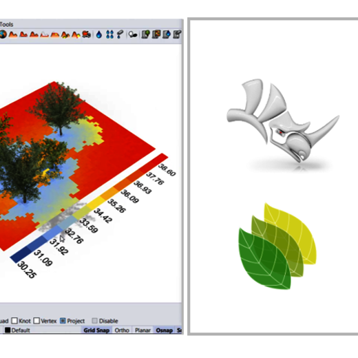
Parametric design with its high potential in connecting data through algorithms to the geometry is getting more involved in the design process.
In this session, you will see some solutions to assess the environmental impacts of a landscape project, by using Lands Design and Grasshopper. Some of these calculations are: CO2 sequestration, the cooling effect, solar radiation, and shadow analysis.
Learning objectives:
- Learn about the general concept of parametric design
- Get an understanding of how parametric design can be used in landscape design
- Learn about the workflow of calculating the environmental impacts of a landscape model
- See the workflow examples of environmental impacts analysis of a landscape: CO2 , cooling, solar radiation and shadow analysis.
Instructors:
- Francesc Salla, Architect and BIM specialist, Product Manager of VisualARQ and Lands Design at Asuni. (fsalla@asuni.com)
- Verena Vogler, Head of R&D McNeel Europe, verena@mcneel.com
-
Landscape modeling and BIM workflow | LandsDesign
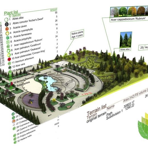
This workshop gives you an insight about drawing and landscape modeling workflow with Lands Design. During the session you will see how a landscape design project develops from drawing to a 3D model.
The software's key features will be addressed including tools for topography (terrain), hardscape, vegetation, visualization, documentation and BIM workflow.Learning objectives:
- Learn how to model a landscape with 3D modeling tools in Land Design, including how to create and edit terrains, insert vegetation elements, and work with hardscape tools.
- View the project documentation process: generate drawings and lists of materials.
- See how Grasshopper integration works: how to automate a parametric design process with Grasshopper's Lands Design components.
- Get a preview of the visualization tools: animations, rendering options and virtual tours.
- Hints of how to run Lands Design as a Revit plugin with the Rhino.Inside technolog
Instructors:
- Elham Ghabouli, Ph.D. in Urban and Architectural management, Landscape Architect. Product Manager at Asuni. (elham(at)asuni.com)
- Francesc Salla, Architect and BIM specialist, Product Manager of VisualARQ and Lands Design at Asuni. (fsalla@asuni.com)
-
UAVs in LA and Landscape Planning
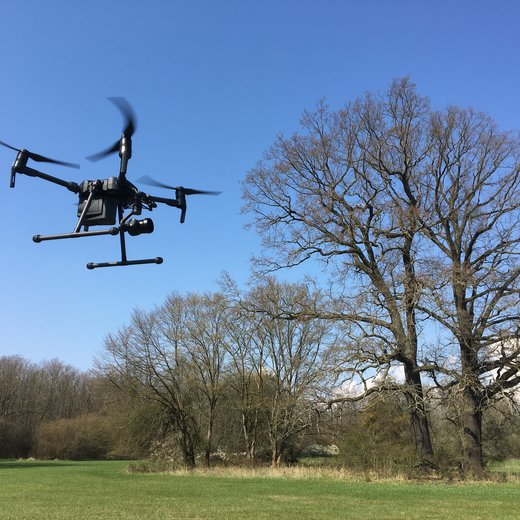
A pipeline from data collecting to modeling and analyzing using Drone (UAVs)
The use of unmanned aerial vehicles (UAVs) can greatly enhance the process of landscape architecture and planning, from capturing aerial images to using photogrammetry, mapping and classification techniques.
This workshop aims to demonstrate how data is acquired, processed, and analyzed, and will highlight various practical applications. Topics will include an overview of different types of UAVs and sensor systems, the procedures for creating orthophotos, surface models, point clouds, and mapping and classification, as well as considerations for resolution and accuracy.
The future use of UAVs in landscape architecture, landscape planning, and nature conservation will be discussed, as well as potential future developments and integration opportunities in education programs for these fields.Instructors:
- Jozef Sedlacek, PhD., AKM - landscape modeling lab, Department of Landscape Planning, Mendel University in Brno, Czech Republic
- Radim Klepárník, AKM - landscape modeling lab, Department of Landscape Planning, Mendel University in Brno, Czech Republic
- Dae Yong Kim, Master of Arts, Research Group Applied Geoinformatics and Remote Sensing, Anhalt University of Applied Sciences, Bernburg, Germany.
- Matthias Pietsch, Prof. Dr., Landscape Architect, Head of Research Group Applied Geoinformatics and Remote Sensing, Anhalt University of Applied Sciences, Bernburg, Germany
-
Digital planning in the 3D city model | VC Planner
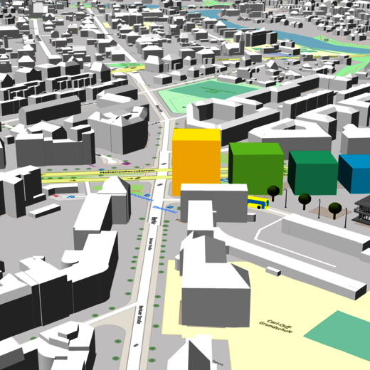
In the workshop "Digital urban planning in the 3D city model with the VC Planner", Virtual City Systems shows how planning scenarios, such as redesigning squares, can be prepared in the 3D city model with the help of digital tools. Participants are given access to the digital planning tool "VC Planner" in order to independently implement a simple planning draft. At the end, we invite participants to present their draft and to discuss it together.
Learning objectives:
- Learn the basics of the Digital Urban Twin concept
- Learn how to use the digital urban planning tool VC Planner, including importing 3D objects into a 3D city model and designing a simple planning scenario
- Get an overview of functions and analytical tools in Digital Urban Twin
Instructor:
- Henry Farr, Marketing Manager at Virtual City Systems GmbH, Master of Science in Urban Studies 4CITIES Erasmus Mundus Program
-
Applying BIM Workflows
Applying BIM Workflows to Sustainable Site Design and Documentation
Building design professionals are increasingly adopting Building Information Modeling (BIM) in their projects and asking Landscape Architects to use the same processes. This workshop will introduce site-specific BIM processes and describe how current technology supports Landscape Architecture professionals as they use these workflows in their site design, analysis and documentation.
Learning Objectives/Outcomes:
- Participants in this workshop will Learn how imported files from allied professionals can be converted to information modeling objects, such as digital terrain models (DTM), from which design and analysis can proceed.
- Discover how quickly parametric objects, like walls with constructed components, can be utilized to affect the other smart hybrid objects in proposed site development.
- Realize efficiencies gained by using referenced viewport tools to develop enlarged plans and live section views, further linking documentation throughout the project.
Instructor:
- Eric Gilbey, PLA. Product Marketing Manager - Landscape Industries