Digital technologies can bridge the gap between nature conservation and Agriculture. Take the protection of endangered bird species, for example. Researchers at Anhalt University of Applied Sciences, led by Prof. Dr. Matthias Pietsch, have tested how meadow-nesting birds can be tracked using unmanned aerial vehicles—such as drones.
Digitalization in Nature Conservation: The Case of Meadow-Nesting Birds
-
 © HS Anhalt
How Does Remote Sensing Help Protect Meadow-Breeding Birds? The Project at a Glance*
Why This Research Topic Is Important
Drones, thermal imaging cameras, and software: These tools could make it easy to locate nesting birds in fields or grasslands. Using the coordinates, farmers could drive around the nests. Endangered meadow bird species such as the lapwing or curlew would be spared. Yet, on a broad scale, this option has hardly been utilized so far. One reason is the lack of established processes for integrating the technology into everyday agricultural work. This is because various factors must be taken into account, ranging from the correct flight altitude of the drone to reliable data transmission to the tractor.
What the Research Has Shown
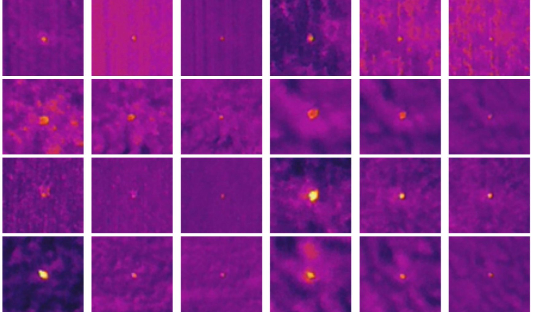
Over various time periods beginning in 2020, researchers at Anhalt University of Applied Sciences used unmanned aerial vehicles (UAVs) to survey various fields and grasslands. The result: The thermal images captured during these flights are an effective way to detect nesting birds and their nests. They identified the following as optimal conditions:
- a flight altitude of 30 to 40 meters
- a solid cloud cover, and
- the early morning hours
Slower flights at a constant altitude disturb nesting birds the least. Smaller songbirds and their nests, as well as nests in tall grass toward the end of the breeding season, were the most difficult to detect. Automated detection using artificial neural networks was also a focus of the project. The researchers tested how thermal imaging data could be effectively transmitted and utilized in three scenarios. All three reliably delivered the information to the farmer in the field of agriculture. Which approach is right for a particular farm depends on its capabilities and resources.
How the Results Can Be Used
The team led by Prof. Dr. Matthias Pietsch discussed and published the results of its initial investigations in the 2023 volume “Remote Sensing and Drone Use in Nature Conservation and Grassland Management.” The volume addresses key practical questions for anyone committed to nature conservation through smart farming. This includes technical details and workflows. The three scenarios for data transmission were developed later and have not yet been published. Prof. Dr. Matthias Pietsch recently described them in this LinkedIn post.
 © HS Anhalt
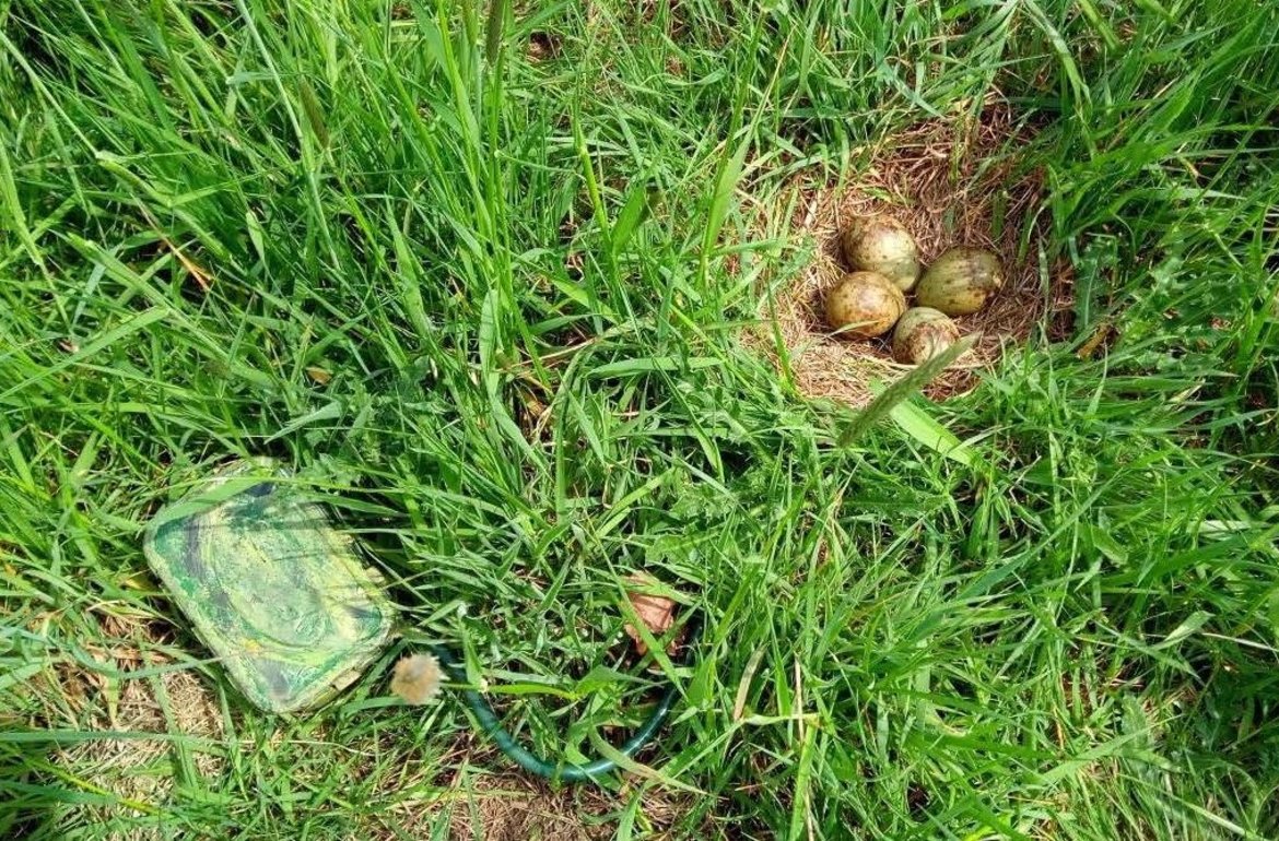
Finding the nests of meadow-nesting birds in tall grass is a particular challenge. Here, a curlew (Numenius arquata). The researchers placed the recording device near the nest to measure the bird’s heart rate.
Protecting Meadow-Breeding Birds in the Future: An Outlook with Prof. Dr. Matthias Pietsch
Prof. Pietsch, how do your studies contribute to nature conservation?
Currently, protecting meadow-nesting birds is very labor-intensive. Mowing continues to destroy nests. Consequently, a great workload is involved in locating nests—for example, those of the Eurasian curlew—on site and fencing them off to protect them. However, nests are still being overlooked. As we have demonstrated, using thermal cameras and analyzing the resulting data would make this process significantly more effective and reliable. Such technologies need to be used more widely, and we intend to continue contributing to this through our research. There are already many good examples of the use of digital technologies in nature conservation: the detection of threatened habitats or habitat types under the Habitats Directive, the monitoring of the health of existing forest stands, the determination of movement patterns of selected wildlife species, and the analysis of multiscale remote sensing data, that is, from satellites, aerial photographs, and drone imagery, in combination with other geodata such as weather, soil, or groundwater data. Based on the collected data, effective monitoring is possible, which not only identifies changes but also allows for evaluating the success of nature conservation measures. A wide variety of methods are available for this purpose.
Your project is based on a well-known technology. The insights you’ve shared in numerous workshops and presentations relate to its application. Do we need more information like this to finally make broad use of digital possibilities? What do you see as the key obstacles?
There is a wide variety of technologies and methods for collecting and analyzing geodata. Extensive research projects are being conducted in this area. Transferring these findings into practice poses a major challenge. This requires presenting the results in a form that is generally understandable and tailored to practical needs. At the same time, it is necessary to inspire practitioners to recognize the potential of these technologies. For this reason, the transfer of knowledge and expertise is of great importance and should be given even greater consideration in the future when planning and implementing research projects, particularly in practice-oriented research.
Even though artificial intelligence proved to be resource-intensive in your study, will the automated analysis of data play a role in practical nature conservation in the future?
Various object- or pixel-based classification methods have long been used in the analysis of remote sensing data. In addition to supervised classification methods, a range of techniques from the field of artificial intelligence can now be employed. For example, machine learning methods such as the Random Forest—which is based on decision trees—are used to identify land-use classes. Deep learning image labeling relies on the use of neural networks. This involves using large amounts of satellite or aerial imagery to train the neural network. This allows large quantities of images to be analyzed automatically; however, sufficient training data is also required. This was also an issue in the meadow-nesting bird project. Another frequently used model is the so-called “Convolutional Neural Network” (CNN). This enables large amounts of data to be analyzed with a high degree of accuracy. These models are used, for example, to identify objects such as individual trees, locations of specific species, buildings, etc. It is expected that such models will be used even more extensively in the future.
 © HS Anhalt
More on these topics:
... Nature conservation, climate protection, digital technologies
Functioning ecosystems have been proven to be important for the climate. They include a wide variety of species, each of which provides important ecosystem services. The role that birds play in ecosystems can be read about on the website of the Senckenberg Society for Nature Research, for example. The Eurasian curlew is described here as a particularly endangered species—a meadow-nesting bird that researchers at Anhalt University of Applied Sciences were able to track very goodly using thermal imaging data. Overall, biodiversity research indicates that the bird population in fields and meadows has already declined by 30 percent over the past 24 years and will continue to decline. For this reason, nature conservation and climate protection measures are increasingly being considered together. And more and more often, this involves the use of digital technologies. The Federal Agency for Nature Conservation, for example, supports research and initiatives on the use of digital technologies to better protect species and habitats. On its website, it lists projects such as apps, networking platforms, and data management tools. The agency’s own publication summarizes the current state of affairs: https://www.bfn.de/digitale-anwendungen
... Research and Knowledge Transfer in Applied Geoinformatics and Remote Sensing at Anhalt University of Applied Sciences
Research, continuing education, conferences: Under the direction of Prof. Matthias Pietsch, the Applied Geoinformatics and Remote Sensing Research Group at Anhalt University of Applied Sciences has been committed for many years to the application of digital technologies in urban and environmental planning as well as in nature conservation. As recently as May 2023, the group hosted the international conference “Digital Landscape Architecture.” Workshops are regularly offered for practitioners from municipalities and associations. Topics of recent publications included “Remote Sensing and Drone Use in Nature Conservation and Grassland Management” as well as a guide to compiling land-use plans compliant with XPlan in Saxony-Anhalt. All ongoing research projects are documented here: https://www.hs-anhalt.de/hochschule-anhalt/loel/forschung/angewandte-geoinformatik-und-fernerkundung/projekte.html
Prof. Dr. Matthias Pietsch:
- has been teaching and conducting research for many years in the fields of geoinformatics and remote sensing, with a focus on environmental planning and nature conservation
- leads the Applied Geoinformatics and Remote Sensing Research Group, which has organized a series of nationally and internationally recognized conferences and published numerous works in recent years.
- Key research areas have included: XPlanung for Landscape Planning, remote sensing, and the use of drones in Nature Conservation and Grassland Management
- More information and related links can be found on his personal page: https://www.hs-anhalt.de/hochschule-anhalt/service/personenverzeichnis/person/prof-dr-matthias-pietsch.html
Additional articles on the use of digital technologies and remote sensing can be found on Anhalt University of Applied Sciences’ KlimaBlog under the topic “Climate Adaptation in Municipalities and Organizations.”
Additional articles on Prof. Dr. Matthias Pietsch’s research:
Climate Adaptation Through Remote Sensing: How Data Can Help
Redaktion
Prof. Dr. Matthias Pietsch
... can be reached for questions and inquiries by phone at +49 (0) 3471 355 1140 or by email at matthias.pietsch(at)hs-anhalt.de
Current publication: Monitoring as a Basis for the Development of Resilient Landscapes: Where, How, and Why? / Pietsch, Matthias. Published in: Journal of Digital Landscape Architecture, Vol. 9 (2024), pp. 534–541.
The cover image shows various meadow-nesting birds that were detected using a thermal imaging camera.
*The research was part of the project “Farming 4.0 in Grasslands: Sustainable Use and Enhancement of Biodiversity through the Use of Unmanned Aerial Vehicles (UAVs),” abbreviated as BIOSENS.NATURA2000. It was funded by the Federal Ministry of Education and Research (BMBF).
