How can heat be made visible - and in 3D? Prof. Dr. Marion Pause and her team are researching new solutions for the practical use of 3D thermography to create models of cities and landscapes. This data helps in the planning of energy-efficient buildings and adaptations to climate change. In an interview on the Anhalt University of Applied Sciences climate blog, she explains current challenges and future benefits.
Heat in 3D: Remote sensing for urban and landscape planning
-
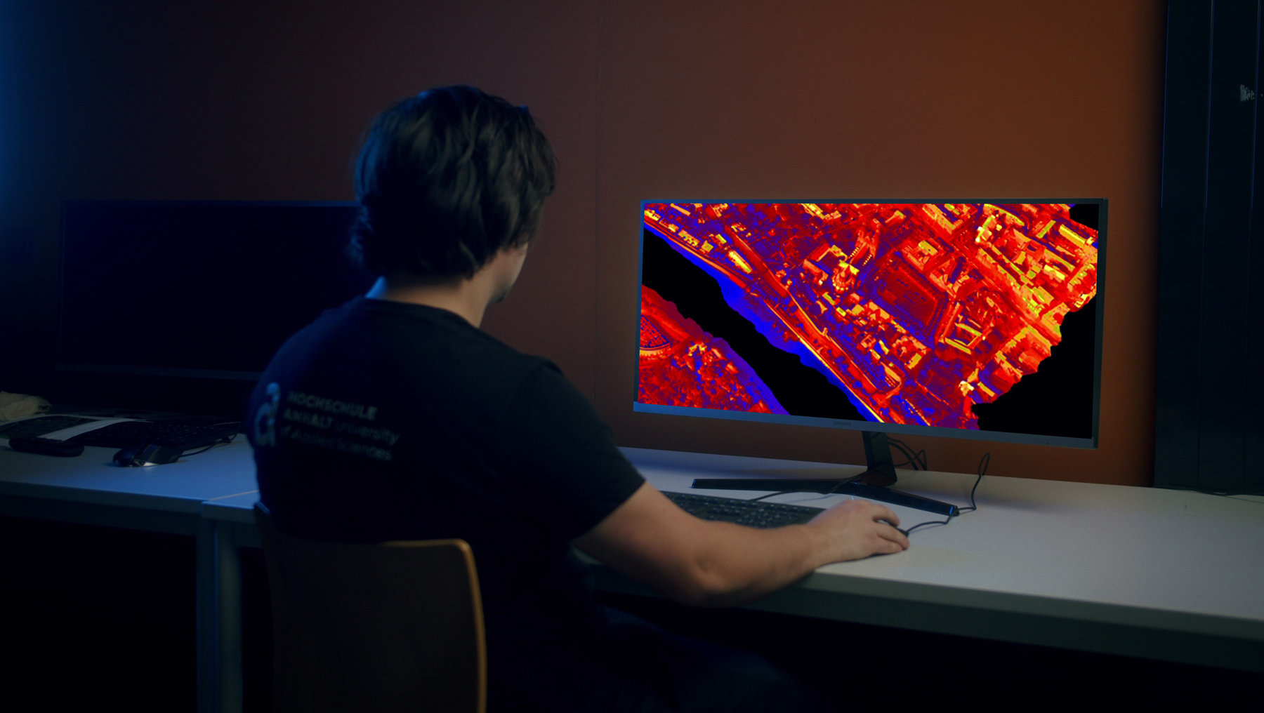 © hochschule anhalt
Using 3D thermography, we provide a new dimension in observations and measurement data.
Prof. Dr. Marion Pause
Prof. Pause, what is the difference between 3D thermography and conventional 2D thermal imaging? Why is it so important for urban and energy planning?
The thermal properties of 3-dimensional objects can be recorded directly, for example building facades. The thermal properties of buildings, which result from their use or renovation status, are of increasing importance, especially in city centers and residential areas. Using 3D thermography, we provide a new dimension of observations and measurement data. The data - not simulations - can therefore be used for exploration, assessment and monitoring.
How does the Aero Oblique System (AOS-T) work and what are the technical challenges involved in capturing 3D thermal data?
With the AOS-T, four RGB and four thermal cameras record data simultaneously in oblique view and in four different directions. The technical challenges include the correct geometric registration of the eight different simultaneously recorded image data. In addition, the thermal data is influenced by numerous environmental conditions, such as humidity and wind, as well as the recording geometry.
What part did Anhalt University of Applied Sciences and the Photogrammetry and Remote Sensing working group play in this development?
The prototype development was initiated and realized by my predecessor Prof. Dr. Lutz Bannehr together with the company ATS Berlin. The task now is to supplement the available hardware - the AOSTx8 prototype - with evaluation software. For this purpose, sensor-specific models must be developed and implemented on the software side in order to enable reliable and convenient use for the user. For example, direction- and distance-dependent aspects that influence the measurement of thermal radiation must be corrected. There is currently still a need for research for this essentially physics-based modeling, which is to be mastered as part of doctorates and R&D projects at the Institute for Geoinformation and Surveying at Anhalt University of Applied Sciences and in the Photogrammetry and Remote Sensing working group.
Hannover Messe 2025 video: 3D thermography for the digital twin with the AOS-T
What specific applications already exist for 3D thermal data in cities or landscapes? Especially in relation to our region?
Data on thermal properties in urban areas, particularly in densely built-up areas, is an important data and planning basis for heat-resilient urban planning. The three-dimensional building models can be used, for example, for credits on the renovation status and energy efficiency of buildings. In addition to taking stock, the data can also be used in future to assess the effect of measures that have been implemented, such as a conversion. In the landscape, for example in the agricultural landscape, the three-dimensional thermal data can be used to investigate the effect of landscape structural elements such as hedge structures and rows of trees on the microclimate. The effect of measures can also be assessed using 3D thermal data, such as special plantings or agriforest.
What role does remote sensing generally play in adapting to climate change, especially in urban areas?
Remote sensing plays a central role because it can provide crucial measurement data. Remote sensing by satellite and airplane is basically the only way to collect large-scale comparable data. The spatially explicit localization and visualization of the measurement data allows patterns to be made visible on the land surface that cannot be seen on the ground with the usual human view of our environment. The interaction of green, blue and gray infrastructure on the temperature of the land surface becomes immediately visible. We can see and measure the cooling effect that a tree, for example, has on the neighborhood.
With the help of remote sensing, the interaction of green, blue and gray infrastructure on the temperature of the land surface becomes directly visible.
Prof. Dr. Marion Pause
How can this data be used for political decisions and urban planning processes?
As remote sensing data are physically based and standardized observations, they represent a reliable basis for decision-making. In particular, the possibility of visual interpretation makes remote sensing data an effective means of communication. Temperature patterns on the land surface can be visualized and directly linked to existing forms of use.
What developments do you expect in the coming years for 3D thermography and its use in practice?
The current increase in demand for 2D thermal data also promises an increase in demand for 3D thermal data. The method of oblique imaging for 3D object modeling is already possible with numerous drones. There is a market for this. However, drones are very limited in their use and airborne 3D thermography can also be used to provide data of entire urban areas quite efficiently.
Research into 3D thermography with the AOS-T at the Hannover Messe:
Prof. Dr. Marion Pause will also be presenting her research at the Hannover Messe from March 31 to April 4. Here, Anhalt University of Applied Sciences will be presenting itself together with Otto von Guericke University Magdeburg, Magdeburg-Stendal University of Applied Sciences and Harz University of Applied Sciences as well as the Thuringian colleges and universities at the joint stand RESEARCH FOR THE FUTURE in Hall 2/ Stand C16.
Prof. Dr. Marion Pause...
teaches and researches at Department 3 of Architecture, Facility Management and Geoinformation at Anhalt University of Applied Sciences. More information can be found on her personal page: https://www.hs-anhalt.de/hochschule-anhalt/service/personenverzeichnis/person/dr-marion-pause.html. In August 2024, a first interview with her appeared on the Anhalt University of Applied Sciences climate blog on the topic of "Climate change through the eyes | Part 1": https://www.hs-anhalt.de/hochschule-anhalt/aktuelles/neuigkeit-1/klimawandel-mit-den-augen-von-oben-teil-1.html
Remote Sensing and Photogrammetry at Anhalt University of Applied Sciences...
Anhalt University of Applied Sciences uses state-of-the-art sensor technology to research environmental and climate processes. The Institute for Geoinformation and Surveying at the Dessau site relies in particular on airborne spectrometers. The background is often interdisciplinary research projects to develop sustainable solutions for urban development, environmental planning and Agriculture.
Technical possibilities:
-
Sensors: Airborne imaging spectrometers and FTIR spectrometers
-
Spectral range: 400-2500 nm (imaging spectrometers), 7.4-11.8 µm (FTIR spectrometers)
-
Areas of application: Agricultural landscapes, urban settlement areas
-
Research projects: e.g. DFG INST 458/31-1, DFG INST 458/55-1, AgriRestore
Redaktion
Prof. Dr. Marion Pause
... is available for inquiries and requests by phone: +49 (0) 340 5197 1564 or by e-mail: marion.pause(at)hs-anhalt.de
... current publication: Monitoring water diversity and water quality with remote sensing and traits / Lausch, Angela. - Included in: Remote sensing, vol. 16 (2024), 13, pp.1-47 | https://www.mdpi.com/2072-4292/16/13/2425
... more about her topics and tasks at Anhalt University of Applied Sciences at the end of the interview
