Information about the degree program
The practically oriented master's degree program in Landscape Architecture and Environmental Planning is divided into:
- four compulsory modules that are carried out as interactive seminars,
- a studio component that focuses on supervised independent project work in a team and
- the master’s thesis including a colloquium.
In the degree program and on the Bernburg campus, there is a pleasant and personal atmosphere for studying and working that is characterized by intensive supervision of your studies.
Students, lecturers and staff are friendly and quick to get in touch.
Study structure and procedure
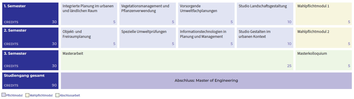 © HSA
© HSA
Qualification objectives and focus of the compulsory modules
Qualification objectives and learning outcomes
The module "Integrated Planning in Urban and Rural Areas" equips students with technical, methodological and conceptual skills for the planning, design and development of sustainable landscapes in urban and rural contexts. Participants are enabled to overcome current and future challenges in spatial planning and landscape architecture through innovative, sustainable approaches and strategies. The aim is to enable students to independently develop integrative planning concepts that take equal account of ecological, economic and socio-cultural aspects.
The module focuses on
- The ability to carry out independent scientific research, analysis and credits for planning processes and concepts in the context of urban and rural areas.
- The development of concepts to promote sustainable development through the use of interdisciplinary approaches and the integration of participatory planning methods.
- The ability to work on planning tasks in a conceptually and methodologically sound manner, taking into account current national and international standards, norms and laws.
Curriculum focus
- Concepts of integrated planning: Theoretical and practical examination of integrative planning approaches that take into account both urban and rural characteristics in order to ensure sustainable spatial and settlement development.
- Sustainable water and precipitation water management: Development and implementation of concepts for efficient precipitation water management, including modern approaches to the management, purification and use of rainwater and surface water.
- Watercourse development planning and revitalization: Analysis and planning for the ecological improvement of watercourse systems, including measures for renaturation and increasing the experienceability of urban watercourses.
- Resource conservation and circular economy: Strategies and concepts for minimizing resource consumption and implementing circular economy principles in the planning and development of construction and settlement projects.
- Local energy supply: Development and integration of concepts for a decentralized, renewable energy supply in spatial and urban planning, including the use of solar energy, wind power and biomass.
- Multimodal transport concepts: Planning and implementation of efficient, integrated transport systems that seamlessly connect different means and modes of transport and thus enable improved mobility in urban and rural areas.
- Participatory planning and public involvement: Methods and strategies for actively involving the population in planning processes, with the aim of promoting transparent, inclusive and sustainable decisions.
The interdisciplinary orientation and the combination of theory and practice prepare students to identify and analyze complex challenges in spatial planning and to develop innovative solution concepts aimed at the sustainable development of urban and rural areas.
Qualification objectives and learning outcomes
In this module, the focus of in-depth technical and methodological skills development is on the acquisition of specialist knowledge and scientific methods and their application in the field of vegetation management and plant use (vegetation development in the context of open space planning, planting planning as part of project planning, green space maintenance management).
By completing the module, you will acquire competencies in the sense of the "General qualification objectives and learning outcomes" described below and additional in-depth competence development for individual profile building will take place according to your choice of a specialization area in the course of completing the examination prerequisite (LNW) and the examination result.
General qualification objectives and learning outcomes
Specialist skills
They deepen their specialist knowledge in the field of vegetation management (planning, planting, development, maintenance, monitoring/success control) as well as plant use in the context of sustainable design and maintenance of open spaces in urban/settled areas and can apply this knowledge confidently.
Methodological skills
You will be able to plan the establishment, development and maintenance of vegetation in the overall context of the management of vegetation/green spaces in populated areas and prepare the necessary documentation for the implementation of the measures required for this.
In this context, you will be able to
- analyze and credit vegetation stands in their entirety with regard to their ecological, social-use-related and cultural-aesthetic functionality as well as specific vegetation areas/systems with regard to their condition based on sound methods,
- to develop a mission statement and guidelines for the development and maintenance of vegetation stocks in populated areas (concept) and to formulate specific development and maintenance goals based on this,
- plan measures to implement the mission statement and achieve the development and maintenance goals (design and implementation planning, approval planning if necessary, specifications, etc.; including cost planning) and
- define criteria and measures for monitoring and success control.
Social-communicative skills
You will be able to independently acquire in-depth specialist knowledge through source research/analysis and evaluation as well as knowledge processing, prepare this specialist knowledge in a structured manner for a research presentation on an assigned topic, present it to a specialist audience in a medially appealing and verbally confident manner and participate in specialist discussions.
They acquire social and communication skills in relation to the completion of tasks in a team as well as the presentation and defense (discussion) of results and solutions.
Profile-building qualification objectives and learning outcomes (compulsory elective)
You will deepen your specialist and methodological skills for individual profile building as part of your time spent independently studying by setting a focus when completing the examination prerequisite and completing the examination (term paper).
Research presentation on an assigned topic (examination prerequisite, LNW)
You choose a presentation topic from a catalog of the following areas of specialization or propose a presentation topic within these areas:
- Area of specialization A: Plant use and planting planning
- Area of specialization B: Green space and green space maintenance management
Term paper (examination)
You will work on a practical assignment in a specific field, which has been formulated on the basis of questions from practitioners from an academic-scientific point of view and focuses on one of the following areas of specialization:
- Area of specialization A: Plant use and planting planning
Creation of a planting concept for a selected open space including design concept, planting plans, cost estimate (according to DIN 276:2018) and service specifications (planting, completion and development maintenance of the planned vegetation)
- Specialization area B: Green space and green space maintenance management
Creation of a vegetation concept including a maintenance manual for the maintenance of existing and/or planned vegetation in a selected open space, including maps, master data sheets, maintenance calendar, cost estimate (according to DIN 276:2018) and list of services.
Curriculum focus
In addition to the classification of the contents of the module in the professional field of Landscape Architecture and Environmental Planning, the following topics form the curriculum focus of the module:
Introduction and specialist knowledge
- Dynamics and durability of vegetation
- Life cycle of urban vegetation and its management
- Vegetation concepts/systems/images including their systematics (e.g. OK-Frei),
- Special vegetation systems, e.g. living walls, swimming ponds, rainwater management, etc.
- Legal framework conditions for vegetation management and the use of plants
- Current and international trends in the use of plants
Methods and tools
for creating development and maintenance concepts for vegetation and green spaces in urban/populated areas:
- Analysis and credits of vegetation in its entirety in a planning area with regard to its ecological, social-use-related and cultural-aesthetic functionality (e.g. SWOT analysis etc.),
- Analysis of the framework conditions and the interests of stakeholders,
- Development and formulation of a mission statement and guidelines as development and maintenance goals as well as fields of action and strategies for vegetation development,
- Analysis and credits of specific vegetation stands and green spaces
- (assessment, image quality catalog, tree inspection, etc.)
- Conception and planning of concrete measures to implement the mission statement and achieve the development and maintenance goals (object/planting planning or maintenance manual along with cost estimates and service specifications),
- Creation of a success monitoring concept including monitoring obligations
Application of specialist knowledge, methods and tools
in the course of preparing the necessary documentation and documents with regard to the
- Approval and implementation of measures as well as
- Tendering, awarding and invoicing of services for the creation, development and maintenance of vegetation and green spaces in urban/populated areas.
Learning outcomes
As part of this module, students acquire in-depth knowledge and skills in the areas of preventive environmental planning and its instruments. They learn to develop and coordinate environmental planning independently and to communicate and defend its results effectively to stakeholders such as authorities, the public and political bodies. The integrative role of environmental planning, which is a cross-sectional task in landscape architecture, is particularly emphasized. Students understand and internalize the importance of sustainability, climate protection, resource conservation as well as nature and species conservation in all phases of the planning, execution and maintenance of open spaces as a core component of all study modules.
Curriculum focus
I. Formal and precautionary environmental planning instruments in the context of landscape architecture:
- Explanation of landscape planning in accordance with the Federal Nature Conservation Act, including all sub-plans such as landscape program, landscape framework plan, etc.
- Development of municipal noise action plans in accordance with the Environmental Noise Directive.
- Development of management plans and programs of measures in accordance with the Water Framework Directive.
- Conception of flood hazard and risk management in accordance with the Water Resources Act.
- Integration of environmental concerns and climate protection into urban land-use planning in accordance with the Federal Building Code.
II. Informal environmental planning and processes:
- Development of municipal sustainability strategies and educational concepts for sustainable development.
- Preparation of specific environmental assessments and planning, particularly in relation to individual protected assets.
- Concepts for "temporary nature" on inner-city brownfield sites and for unsealing measures to improve precipitation management.
- Planning for the implementation of the "sponge city" and for climate impact management, especially to minimize overheating in settlement areas.
- Development of city-wide green and open space concepts/master plans for green spaces and the environment.
- Participation in environmental planning contributions to comprehensive mobility concepts.
Learning outcomes
In this module, students acquire the knowledge and skills to work on landscape design projects from conception to presentation in a practical manner. A realistic work process is simulated in direct exchange with practitioners such as municipalities and planning offices. Students learn to pick up on current trends and challenges in landscape design and integrate them into their projects. They deal intensively with the cultural, visual and ecological dimensions of landscapes and apply complex assessment procedures. They also strengthen their skills in scientific work, project management and teamwork as well as in the use of specialist software.
Course content
- Practical development of landscape design projects with an annually changing focus.
- Application of landscape assessment methods, including visual and ecological credits.
- Promotion of sustainability and environmentally friendly use of plants. - In-depth study of project management, teamwork and effective communication.
Methods
- Interdisciplinary seminars on theory and discussion.
- Realistic project work in cooperation with external partners.
- Team projects to promote collaboration and presentation skills.
The module enables students to develop an in-depth understanding of landscape design and prepares them specifically for their future professional tasks by bridging the gap between theory and practice.
Qualification objectives and learning outcomes
General qualification objectives and learning outcomes
Through theoretical explanations and practical courses, students will recognize the potential of using software (geographic information systems, computer-aided design (CAD)/visualization, etc.) for the continuous/extensive digitization of processes in open space and environmental planning. Students are familiar with relevant information technology standards, concepts such as GeoDesign and Building Information Modeling (BIM) as well as current (technical and professional) standardization projects at European, federal and state level. Students will be able to read and process (edit, analyse, interpret) existing data (geobasis and geospatial data, digital aerial and satellite images, etc.) in software applications and communicate the results generated through appropriate visualization (map creation, 3D visualization, etc.).
They have an overview of the essential software applications for the realization of fully or largely digitized process cycles in the field (planning > realization > maintenance > dismantling/rehabilitation) and the skills to use them safely.
Profile-forming qualification objectives and learning outcomes (compulsory elective)
They deepen their specialist and methodological skills for individual profile formation as part of their time spent independently studying by setting a focus when completing the examination (term paper).
Term paper (examination)
You will work on a practical assignment with a focus on one of the following areas of specialization:
- Specialization area A: Geographical Information Systems (GIS)
Work on a task from the field of Landscape Architecture and Environmental Planning using a Geographic Information System (GIS) - Area of specialization B: Computer Aided Design (CAD) and 3D visualization
Processing a task from the field of open space and object planning in the sense of creating a 3D visualization for an open space in the form of renderings, videos and/or a real-time 3D application.
Curriculum focus
Using selected case studies, you will be taught the complete virtual/digital work process for the field of open space and environmental planning, in particular with regard to the realization of a platform-independent, process-supported flow of information through the appropriate and efficient use of suitable software products.
Furthermore, the qualification objectives of the module are classified in the professional field of Landscape Architecture and Environmental Planning, also with regard to the various professional opportunities and career prospects in this field.
Geographical information systems
- Application of specific software applications for the acquisition and generation of geodata
- Processing different formats of raster and vector data, coding, topological structure, geodatabases
- Georeferencing of aerial images and maps, image mosaic, derivation of landscape-ecological parameters, coordinate systems
- Creation of thematic maps
- Use of specific GIS applications to process questions and tasks in open space and environmental planning as well as in the field of green space management
- Teaching specific methods and procedures from the field of geoinformatics
CAD/visualization
- Relevant standards (BIM etc.)
- Use of software applications from the field of CAD/visualization
- 3D modelling of design concepts and their further processing into high-quality visualizations or real-time applications
Qualification objectives and learning outcomes
General qualification objectives and learning outcomes
You will deepen your specialist and methodological skills in the field of Landscape Architecture and Environmental Planning in the area of object and open space planning.
In this context, you will demonstrate that you are capable of independent:
- scientific research, preparation, presentation and documentation of current issues, concepts or trends in open space planning and lead a scientific discourse in this context,
- work on a subject-specific planning task for a selected processing area at various scales in conceptual, constructive and artistic terms
Profile-forming qualification objectives and learning outcomes (compulsory elective)
You will deepen your specialist and methodological skills for individual profile formation as part of your time spent independently studying by setting a focus in the course of completing the examination (design concept/paper), i.e. you will independently work on a practical task relating to a specific area of work with a focus on one of the following areas of specialization:
- Specialization area A: Open space development/planning
Planning on a conceptual/small-scale level, also in the sense of project development: drawing up a development concept (mission statement, fields of action, master plan, action plan, etc.) for a selected area - Specialization area B: Project planning (work phases 1-3 according to § 39 HOAI)
Processing a complex task in terms of developing a design concept for an open space in a clearly defined area (in accordance with sections 38-40 HOAI) including cost considerations (cost estimation/calculation in accordance with DIN 276:2018)
Curriculum focus
In addition to the classification of the contents of the module in the professional field of Landscape Architecture and Environmental Planning, the following topics on current issues in the field in a national and international context form the curriculum focus of the module:
- Urban open spaces as green infrastructure and providers of ecosystem services,
- Urban ecology: climate change, biodiversity, etc.,
- Current approaches and concepts for urban development, e.g. activating urban development and creative industries,
- Theories, principles and methods for the planning and design concept of urban open space systems of different types at different scales and
- Spatial development, functionalities and user-friendliness of urban open space systems, incl. participation and involvement
Qualification objectives and learning outcomes
General qualification objectives and learning outcomes
You will acquire in-depth knowledge of the tasks and instruments of environmental assessments (strategic environmental assessment (SEA), environmental impact assessment (EIA), FFH impact assessment (FFH-VP), special species protection examination (SAP), impact regulation (ER)). This enables them to independently prepare environmental reports (EIR), environmental impact studies (EIS), landscape conservation plans (LCP), FFH impact studies (FFH-VS) and species protection reports (SPR). Special regulations, requirements from case law and practical examples are discussed with the students.
They will be able to prepare the technical assessment materials for SEA, EIA and FFH-VP in the context of approval and planning procedures. In addition, they will be able to participate in the relevant procedural steps (in particular screening, scoping, discussion meeting, decisions on weighing up) as well as assume decision-making and management competencies for the supporting procedures.
Profile-building qualification objectives and learning outcomes (compulsory elective)
You will deepen your specialist and methodological skills as part of your time spent independently studying by setting a focus for the examination prerequisite and completing the oral examination in one of the following areas of specialization:
- Area of specialization A: Strategic environmental assessment and environmental impact assessment
- Area of specialization B: Impact regulation
- Area of specialization C: FFH impact assessment and special species protection examination
Curriculum focus
In addition to the classification of the contents of the module in the professional field of Landscape Architecture and Environmental Planning, the following topics form the curriculum focus of the module:
- Impact regulation according to BNatSchG
- Strategic environmental assessment and environmental impact assessment in accordance with UVPG
- Environmental assessment according to BauGB
- FFH impact assessment and special species protection examination in accordance with the BNatSchG
- State-specific supplements to the UVPG (examples of state UVPGs)
- Classification of the environmental assessment instruments in the approval procedure
- Preparation of the content of the scoping meeting
- Interaction between project developer, planner, approval authority and environmental authorities
- Multi-stage EIA (regional planning procedure and approval)
- Service profiles according to HOAI and fee calculation
- Determining the scope and area of investigation
- Examples in accordance with BauGB, Circular Economy Act, BImSchG etc.
Learning outcomes
This module combines theoretical principles with practical requirements in landscape architecture in order to prepare students for real project situations. By working with external partners such as non-profit institutions and local authorities, students learn how to develop studio tasks taking into account current issues and discussions in the professional field. Annually changing thematic focuses allow flexible adaptation to the dynamic developments within landscape architecture. The aim is to develop and apply a comprehensive understanding of the cultural, visual and ecological aspects of landscapes. Students also learn important methods of landscape assessment, implement sustainable plant uses and strengthen their skills in scientific work, leadership, teamwork and the use of specialist software.
Curriculum focus and curriculum planning
- Application of problem-solving strategies for holistic environmental design.
- Use of computer-aided spatial analysis techniques to explore landscape contexts.
- Development of project management and team-building skills.
- Learning effective communication and presentation techniques for the presentation of planning and design concepts.
Methods:
- Seminars: Consolidation of theories and methods with a focus on practical application.
- Project work: Developing real projects in cooperation with external partners to put theoretical knowledge into practice.
- Group projects: Promote teamwork and the collaborative development of solutions.
The module combines theoretical knowledge with practical implementation in landscape architecture in order to optimally prepare students for the challenges and opportunities of their future professional field.
Qualification objectives and learning outcomes
The main components of the module are
- the preparation and presentation (incl. discussion) of an exposé for the Master's thesis and
- the colloquium for the presentation and defense/discussion of the results of the Master's thesis.
General qualification objectives and learning outcomes
You will acquire skills in scientific work and demonstrate these by being able to develop a complex application-oriented scientific question or task in the field of Landscape Architecture and Environmental Planning for processing as a Master's thesis in the form of an exposé, to present it in a structured textual, graphic, etc. manner and to present it in a colloquium. The main contents of the exposé are
- Introduction: Presentation of the research/thesis topic and its classification in the subject area as well as the professional field, academic and/or practical significance/relevance of the question/task - e.g. with regard to the justification and explanation of the motivation for working on it
- Objective: Aim of the work and interest in knowledge (clear delimitation of the question or task, outline of the expected results)
- State of the art in science and technology: Presentation of the state of the art in research and development / recognized rules of technology / best practice etc. on the topic of the question or task
- Research/work concept: Procedure (work packages/steps, milestones), application of methods including justification, resources required (e.g. data, software, etc.) for processing the question or task, design concept of the table of contents if applicable
- Schedule: Structured tabular representation of the planned procedure for achieving the objective (solution of the question/task) as a chronological sequence of activities, work steps, milestones, etc. in a Gantt chart (bar chart)
- List of sources: Sources used/quoted in the synopsis as well as central/relevant sources - in particular specialist literature on the topic of the question or task
You are able to present the results of your Master's thesis in a formally, linguistically, visually and factually convincing manner:
- as an essay in the type and form of an article/paper for specialist journals, conference proceedings or other collective works and
- through a presentation or research on an assigned topic within the colloquium for the Master's thesis (§ 32 PSO) - structured in a given time using high-quality media
As part of the colloquium, students demonstrate their ability to discuss the results of their Master's thesis in a scientifically and methodologically convincing manner.
Profile-building qualification objectives and learning outcomes
You will be able to deal with a complex application-oriented question and task in a specific sub-area of Landscape Architecture and Environmental Planning as part of the preparation of an exposé for the Master's thesis - also with regard to strategic planning of personal deepening of competences and individual profile building.
Curriculum focus
- Opportunities to develop an individual profile in the field of Landscape Architecture and Environmental Planning and career prospects
- Application-oriented scientific work
- Time planning and self-management
- Development of an exposé on a complex application-oriented scientific question or task as the basis for the Master's thesis, including presentation and colloquium on the exposé
- Presentation and colloquium on the results of the Master's thesis
Qualification objectives and learning outcomes
General qualification objectives and learning outcomes
You will be able to work independently on a complex question or task with an application-oriented scientific approach within a given time, i.e:
- apply specialist knowledge, scientific findings, suitable methods and other resources with confidence,
- present the knowledge gained or results obtained in a textual elaboration and graphical representations in a factually convincing, technically clear, linguistically and formally correct and clearly structured manner,
- derive practice-oriented recommendations for action and conclusions from findings and results, and
- critically reflect on and discuss the knowledge and information on which the Master's thesis is based, the methods and resources used in its preparation and the findings and results obtained.
Profile-building qualification objectives and learning outcomes
In order to deepen their specialist and methodological skills and build their individual profile, they work on a complex application-oriented scientific question or task with a focus on a sub-area of Landscape Architecture and Environmental Planning.
Curriculum focus
Independent processing of a complex application-oriented scientific question or task in the field of Landscape Architecture and Environmental Planning as a Master's thesis, including the formally and linguistically correct documentation and discussion of the approach, applied methods and resources used as well as the results/findings.
Elective modules
Learning outcomes
As part of this module, students deal intensively with the role of recreation in nature and its contribution to nature conservation and landscape management. They discuss different forms of tourism and their significance for internal and external conflicts of objectives in the field of nature conservation. By analyzing case studies, students learn to identify existing conflicts of objectives and develop solutions. In addition, students evaluate the opportunities and risks of sustainable tourism and design concepts that both promote sustainable tourism models and take regional development into account.
Curriculum focus
- Recreation in nature and landscape: Insight into the basic principles of human recreation and its legal framework.
- Landscape recreation provision: Classification and significance in the context of nature conservation and landscape conservation.
- Significance and evaluation of the landscape: Methods of landscape aesthetics and credits.
- Sport and recreation: possibilities and limits of sporting activities in the open countryside.
- Forms of tourism and their influences: Examination of different tourism models and their impact on the environment and regional development, including sustainable tourism and ecotourism.
- Tourism environmental management: strategies and instruments to minimize the negative impact of tourism on the environment.
- Management of tourism destinations: Approaches to sustainable destination management and the role of tourism in protected areas.
The course content is taught using methods such as seminars, project work, group discussions and excursions to a large protected area. These enable students to combine theoretical concepts with practical experience and develop their own solutions to current challenges in nature conservation and tourism.
Learning outcomes
Subject-specific learning objectives:
After completing this module, students will understand basic theories and concepts of planning sociology for urban and rural areas. They are competent in the use of empirical social research methods such as questionnaires, interviews and observations to collect and analyze data on user groups. Students can identify differences in the use of open spaces in different socio-cultural contexts and apply placemaking concepts in a targeted manner. They will also be able to communicate their observations visually and create convincing presentation materials using modern layout software.
General competence goals:
Students acquire the ability to analytically and synthetically process planning sociological theories and concepts. They develop research skills, interpersonal skills and the ability to work in interdisciplinary teams. By collecting, analyzing and presenting data, they improve their application skills in practice and acquire advanced visual communication and planning skills. Students are also able to develop new ideas by applying theories to practical planning issues.
Curriculum focus
- Sociological aspects of planning and design with regard to social requirements and the effects of urban and rural development.
- Examination of the usage behavior of urban spaces, taking into account cultural and social diversity.
- Analysis of population development and sociological effects in urban and rural areas.
- Use of empirical social research methods to collect relevant user data.
- Practical application of placemaking strategies for the revitalization of urban spaces.
- Developing presentation skills through drawing exercises and sketching as well as designing presentation posters with a focus on graphic and color design using Photoshop and InDesign.
This module aims to provide students with a deeper understanding of the sociological aspects of spatial planning and to enable them to develop and professionally present user-oriented and socio-culturally adapted design concepts.
Learning outcomes
After completing this module, students will be able to independently draw up complex maintenance and development plans for protected areas designated under nature conservation law and management plans for Natura 2000 areas. They have the skills to develop, optimize and implement target- and question-oriented monitoring systems in nature conservation. Students will be able to systematically collect and analyze data and create action plans based on this data as well as evaluate the conservation status of habitats and species.
Curriculum focus
- Introduction to maintenance and development planning as well as management planning for nature conservation areas, including the tasks, objectives and classification in nature conservation planning.
- Methods for developing the basis for planning, including data collection and analysis.
- Evaluation of threats, protection worthiness, need and capability of protected areas as well as credits for conservation status and development potential.
- Development of complex target systems for nature conservation planning, including guiding principles and target species concepts.
- Approaches to resolving conflicts of nature conservation objectives and planning specific measures for specific areas.
- Fundamentals of various monitoring systems and their significance for long-term ecological research and environmental monitoring, including early warning systems and measure-related monitoring.
- Design, requirements and evaluation of monitoring systems as well as case studies from practice, e.g. ÖFS, FFH monitoring, EU environmental action monitoring, biodiversity monitoring in Switzerland, species-related monitoring (species aid programs, raptor monitoring, etc.).
This module prepares students to apply theoretical knowledge and methodological skills in practice in order to create efficient and sustainable action plans for the conservation and development of protected areas. It promotes an understanding of the need for comprehensive monitoring systems as a key tool for taking credits for the effectiveness of conservation measures.
Learning outcomes
This module provides students with comprehensive knowledge and practical skills in the use of Global Navigation Satellite Systems (GNSS) and the application of specific remote sensing and GIS software for tasks and issues in Nature Conservation and Landscape Planning. Participants learn to acquire and process digital images using remote sensing technologies and to use and manage raster and vector data effectively.
Curriculum focus
- Basics of GNSS technologies (GPS, Glonass, Galileo) and global orientation with technical permitted supplementary materials for precision mapping.
- Introduction to remote sensing software for obtaining digital images and the playful processing and creation of digital interpretation sketches.
- Detailed treatment of different formats of raster and vector data, including their encoding, topological structure and administration in geodatabases.
- Methods of georeferencing aerial images and maps, creation of image mosaics and thematic maps, and derivation of landscape ecological parameters using relevant coordinate systems.
- Introduction to automatic and step-by-step classification methods, with a focus on their fundamentals and the associated problems.
- Practical application of remote sensing software and GIS tools to answer specific questions in the field of Nature Conservation and Landscape Planning, including the use of GIS methods for data evaluation and interpretation.
Through this module, students acquire the ability to use modern remote sensing and Geographic Information Systems (GIS) technologies in a targeted manner for the effective planning and implementation of nature conservation measures and landscape planning projects. The practice-oriented examination of real-life situations enables participants to improve their technical skills and make them usable for the protection and sustainable development of nature and landscapes.
Learning outcomes
Students acquire in-depth knowledge of the socio-economic, building climate and aesthetic value of green roofs, façades and interior green spaces as well as landscaped stone gardens and waterscapes. They will be able to provide targeted advice to various stakeholders such as building owners, local authorities and housing associations. In addition, students learn the basics of maintenance category systems and concepts and gain an overview of essential maintenance measures. A key focus is on imparting detailed knowledge of plant assortments and their characteristics for specific greening tasks. The ability to assess the prerequisites for successful greening and to make a property-specific plant selection is consolidated by working on practical case studies.
Curriculum focus
- Detailed explanation of maintenance concepts and stages for public and private green spaces.
- Comprehensive care guidelines for alternating plantings, perennials and shrubs, including pruning techniques, fertilization and protective measures.
- Use and effects of indoor greenery on the indoor climate, taking into account greening systems, substrates and plant assortments, as well as care requirements.
- Use and care of potted plants, with a focus on overwintering and plant assortments according to overwintering groups.
- Knowledge of site-specific basics, construction types and plant use in stone plants, especially for dry sites.
- Overview of natural and artificial water body types, including swimming ponds and their limnological principles.
- Basic legal and structural requirements for the realization of structural greenery.
- Selection criteria and site requirements of plants for green roofs and façades, taking into account different types of greenery.
This module provides students with a comprehensive understanding of the importance and implementation of innovative greening techniques in modern urban and landscape planning. The practice-oriented training will train them to become experts in the planning, implementation and maintenance of various greening systems that support the sustainable development of urban and rural areas.
